

Who needs satellite images when you have ground truth? A close-up view of the North Korean long-range rocket and its new missile launch facility.
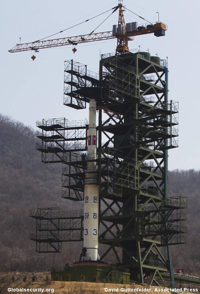
Figure 1. The Unha-3 space vehicle on the launch pad as of April 8, 2012
Globalsecurity.org Photo credit: David Guttenfelder, Associated Press.
The recent announcement by North Korea of its intention to launch a satellite into space on the 100th year anniversary the birthday of Kim Il Sung, has focused international attention on a newly finished missile launch center at Tongch'ang-dong, located about 113 kilometers north of the capital Pyongyang. The launch site is located in "denied territory", that is, anywhere off-limits to the international news media. Until now the media has relied on a relatively new technology, commercial imaging satellites, to try to tell the story. The media used satellite imagery to illustrate the failed space launch in 2009.
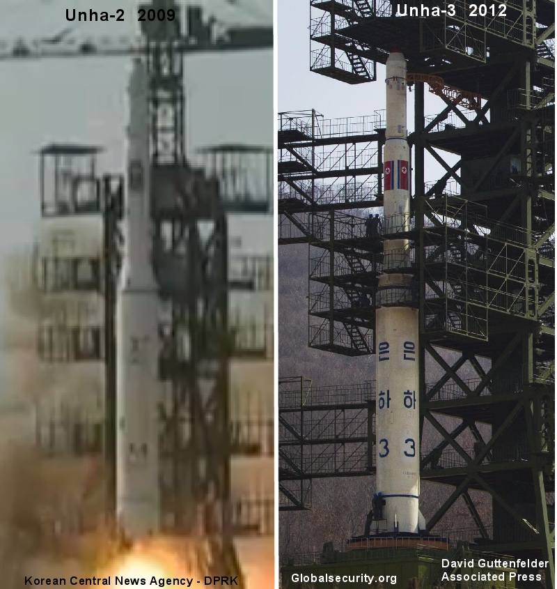
Figure 2. A comparison of the Unha-2 launched in 2009 and the Unha-3. They look almost identical.
Globalsecurity.org Photo credit: David Guttenfelder, Associated Press.
Still, the ability to really understand what happened by using high-resolution imagery is limited. Fortunately, in this case, the U.S. State Department called "on the international community to abstain from...sending observers...that might be seen as endorsing a launch...that would be in blatant defiance of North Korea's international obligations..."
Undeterred by the warning, the international press corps went to Pyongyang, and was taken by North Korean minders to tour the launch site. Previously, we have had to view the new launch site from 200 miles up with imaging satellites hurtling at 4 miles per second. Obeying the laws of Kepler, they are over the site for a few seconds at a time, arriving and departing at the same of day, once every three days. Since the satellite company, DigitalGlobe has three satellites; it can image the site once a day. GeoEye the other American satellite company, with two high resolution satellites can image the site about every other day. Often, the launch site is obscured by cloudy weather for days at a time. Happily, the media's trip has allowed us to view the launch site from the distance of a few hundred meters.
With this "ground truth" image, we no longer have to squint at satellite images trying to guess the height of the Unha-3 missile; it is about 29.5 meters, plus or minus 5 percent. We can see clearly that there are four movable service platforms, each with four levels one either side of the rocket. The movable launch pad is about 2.5 meters high.

Figure 3. To show the size of the Unha-3, an inset showing workers at the base of the vehicle.
Globalsecurity.org Photo credit: David Guttenfelder, Associated Press
Fresh imagery of the launch tower "gantry" shows us that it is just an ordinary tower crane, the kind found at construction sites around the world.
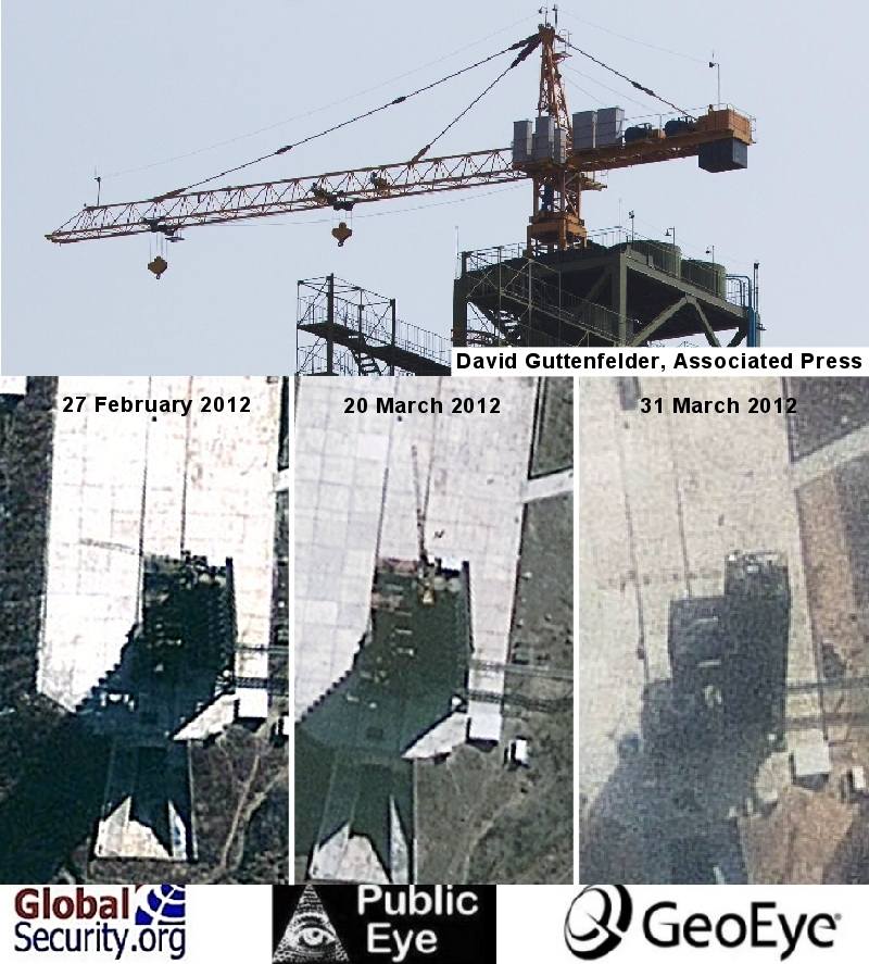
Figure 4. Details of the gantry in satellite imagery are hard to distinguish. Viewed up close, the crane is consistent with those found the world over.
Globalsecurity.org Photo credit: GeoEye,David Guttenfelder, Associated Press
The crane has two sheaves one for farther out on the jib for relatively lighter loads, and one closer in, possibly for stacking the rocket stages. There is some debate, regarding how the rocket is transported from the horizontal check-out building.
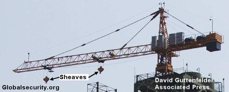
Figure 5. Globalsecurity.org Photo credit: David Guttenfelder, Associated Press.
One view is that it is transported on a trailer as a complete unit. The other view is that it is moved in stages, with each stage "stacked" upon the other until the launch vehicle is complete. Until a transporter is observed, we cannot be certain.
At the top of the tower are two cylindrical objects, that we have observed in satellite imagery, that we now know are tanks holding water that will travel down pipes to be sprayed by nozzles on the flame deflector, to dampen the effects of the rocket blast when it fires.
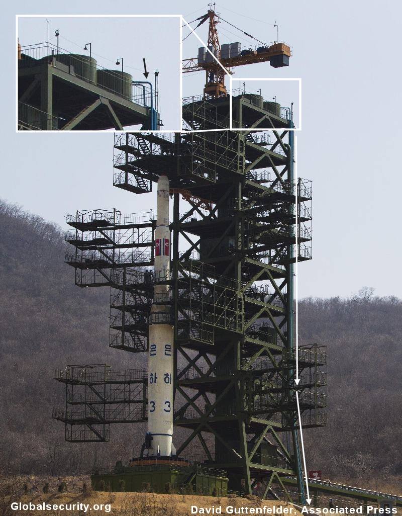
Figure 6. Globalsecurity.org Photo credit: David Guttenfelder, Associated Press.
A close examination of the launch vehicle show several grey panels that might be antennae that transmit telemetry, while in flight, to ground stations. This allows the North Koreans, and presumable US intelligence the ability to monitor and later analysis the rocket engines performance, guidance and steering inputs, and "staging," that is, the separation of each stage the firing of the subsequent engines.
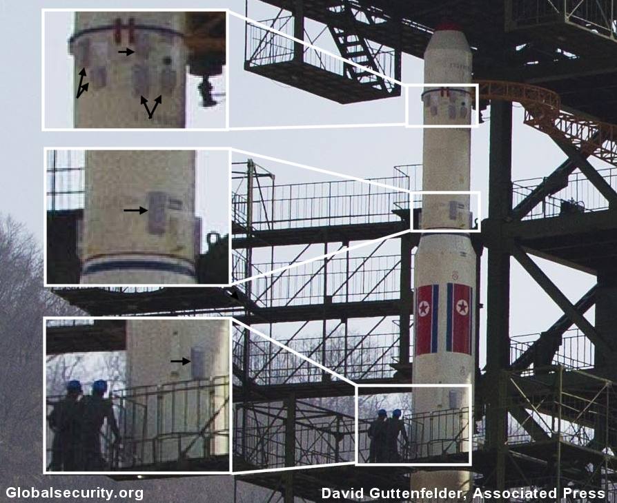
Figure 7. Globalsecurity.org Photo credit: David Guttenfelder, Associated Press.
This telemetry will probably be intercepted by US reconnaissance aircraft, naval vessels, ground stations in the Philippines, and perhaps Australia, and a host of other signals that reveal the overall performance of the flight. If the satellite fails to enter orbit, the boosters and the payload can be retrieved from the ocean floor by specially designed US submarines. Recently Jeff Bezos who founded Amazon.com, located the Saturn V booster from Apollo 11 lying in about 14,000 feet of water off the Florida coast, using sonar. He intends to retrieve it and put it on display.

Figure 8. Globalsecurity.org Photo credit: GeoEye
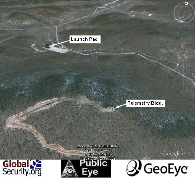
Figure 9. The telemetry site in relation to the launch pad.
Globalsecurity.org Photo credit: GeoEye
Conclusion
This effort gives the North Koreans more experience in launching a satellite. Aside from being a publicity stunt, the know-how that the North Koreans gain from this launch could be used to launch a warhead. That is what concerns the International community and the United States. South Korea and especially Japan are interested as well. All of South Korea is within range of shorter range North Korean No-Dong and SCUD-C missiles. Japan has followed every North Korean missile launch with extreme interest since the failed launch in 1998, when a North Korean Taepodong-1 overflew the Japanese Island of Honshu.
Both countries have been armed with US-built Patriot PAC -3 missiles that could hit an incoming North Korean missile, whether an errant booster or warhead. The US bases on the Islands of Okinawa, and Guam, are also protected with Patriot PAC 3 missiles.
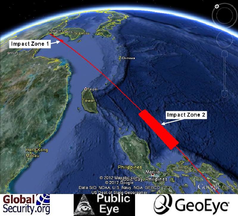
Figure 10. This illustration of the flight plan as submitted by North Korea to the International Civil Aviation Organization. Globalsecurity.org Photo credit: Google Earth.

